During a mountain bike ride, the smartphone can prove to be a very useful ally and also help you feel safer.
The best MTB apps updated to 2021
Discovering routes and trails, planning an itinerary in all its stages, finding other fans to follow and keeping under control important aspects such as weather, safety and athletic performance, are common functions of the apps for MTB among the most downloaded on the App Store or Google Play.
Here then is a detailed overview of specific apps for mountain bikers who are looking for tools with features tailored to their needs.
WHIP LIVE
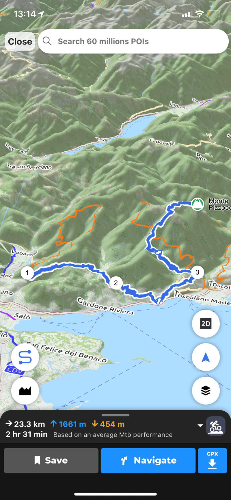
With WHIP LIVE you can plan routes and navigate them , tracking your activity to share with friends and followers. WHIP LIVE's Live Tracking is also complemented by advanced safety features, such as a convenient orientation function, the activation of emergency contacts and the SOS button .
The app is distinguished by its ease of use that masks technical performance, comparable to that of the most sophisticated professional GPS devices, as well as a wide variety of user-generated routes including segments, dirt roads and points of interest.
Try it now www.whip.live/download
Komoot
It offers features purely focused on exploration and travel, declined in the different disciplines supported such as climbing, trekking, bikepacking and mountain biking.
Free the first region. 59 euros / year for unlimited navigation and regions.
From Germany, the Komoot app offers features purely focused on exploration and travel, declined in the different disciplines supported such as climbing, trekking, bikepacking and mountain biking. What is striking about this app is the large amount of information and travel tips, useful for those who love to discover new adventures in any part of the world or "around the corner", as the claim says.
Also useful is the ability to indicate your training level to select the type of route based on difficulty. The basic features of the app are free, while for a fee you can purchase map packs or subscribe to the Premium subscription that includes navigation, live tracking, multi-day route planner and other services.
More info: www.komoot.de
Wikiloc
An extensive database of routes around the world to explore via maps and points of interest. 9.99 euros/year to unlock navigation, advanced search, weather, route list sharing and live tracking.
The world's trails are at your fingertips with Wikiloc, an app linked to a database of countless routes for mountain biking, trekking and other similar disciplines. The app's flagship feature is undoubtedly its trail search engine, which offers navigable maps and offline tracks with specific filters to indicate the duration, difficulty and overall length of the route, or to search by points of interest. To get more technical services such as tracking, navigation and weather, you need to activate a paid Premium account.
More info: www.wikiloc.com
Trailforks
App focused on segment discovery and offline map searching, specifically for mountain bikes, with featured segments and shared stats. At €20/year it offers offline maps, downloadable GPS tracks and unlimited saves.
Trailforks is an app that is particularly specialized in mountain biking, with a database of routes that are in-depth in every detail, with the addition of information derived from the experiences of users. Every uphill or downhill stretch is highlighted on the map with altimetry, distance and average time. The only flaw is that to add your own content for the benefit of the community you must use the desktop version. This is an app focused on segment discovery and offline map searching, so to make the best use of it you should integrate it with other devices. Trailforks also has a premium version that expands the choice of maps and features available.
More info: www.trailforks.com
AllTrails
App dedicated to the discovery of trails and itineraries with the possibility to select different types of vehicles and indicate them among the search filters. In the pro version at 29.9 euros / year the services of real-time tracking, offline navigation and map overlay.
The AllTrails app is connected to the famous portal dedicated to itineraries to be traveled by bike, on foot or on horseback, addressing itself primarily to those who travel and look for new paths to explore. Among the search filters, it is possible to indicate your preferred means of transport and choose the level of difficulty of the route, the length, type and altitude, as well as other interesting details such as community rating, the presence of selected points of interest and the accessibility of the route to children, animals or wheelchairs. In its Pro version, the app offers the ability to browse maps offline, enable live tracking for safety (called Lifeline in this case) and voice notifications to assist with navigation.
More info: www.alltrails.com